Loop Trails Bring Safer, More Enjoyable Hiking to NJ Parks
Title

Body
Networks of marked trails usually grow organically over many years, with additions of new spurs and connectors that can eventually lead to confusing webs of different trail markings. While long-time hikers in an area take these gradual changes in stride, the final product can be overwhelming to someone new.
Over the past few years, a concerted effort has been made to identify and improve trail networks in several New Jersey parks that have disproportionate numbers of lost hikers. Ramapo Valley County Reservation was the first park to undergo these changes under the leadership of Trail Conference volunteers and staff. In addition to clarifying trail networks by combining shorter trail segments into larger, coherent loop hikes, these improvements have also included strategic new trail connections that opened up expanded hiking possibilities. In areas seeing spiking visitation and persistent issues with lost hikers, these changes have helped keep novice trail users safe while providing more opportunities for veteran outdoor enthusiasts. It’s a win-win for everyone.
This year, additional trail networks are receiving similar attention. Based on input from hikers, volunteer leaders, Trail Stewards, search and rescue personnel, and park staff, the Trail Conference has been able to improve the experience in Ringwood State Park, Ramapo Mountain State Forest, Abram S. Hewitt State Forest, and Wawayanda State Park’s Terrace Pond area by reblazing trails. No new trail construction was necessary for most of these trail network revisions, with paint and brushes being the only tools needed.
While on-the-ground implementation only began this season, making these changes possible was a long-term project. Over the past two years, Trail Conference volunteers and staff spent countless hours discussing, planning, scouting, and obtaining state park approval for these projects. This summer’s rapid burst of in-the-field activity was the culmination of all that diligence. Chief among our state park partners are New Jersey State Park Superintendents Jessica Krugel and Eric Pain. Jessica and Eric both have a long history of support and cooperation that has allowed the Trail Conference to tackle otherwise impossible projects, and these re-blazing efforts are the latest successes in our partnership together.
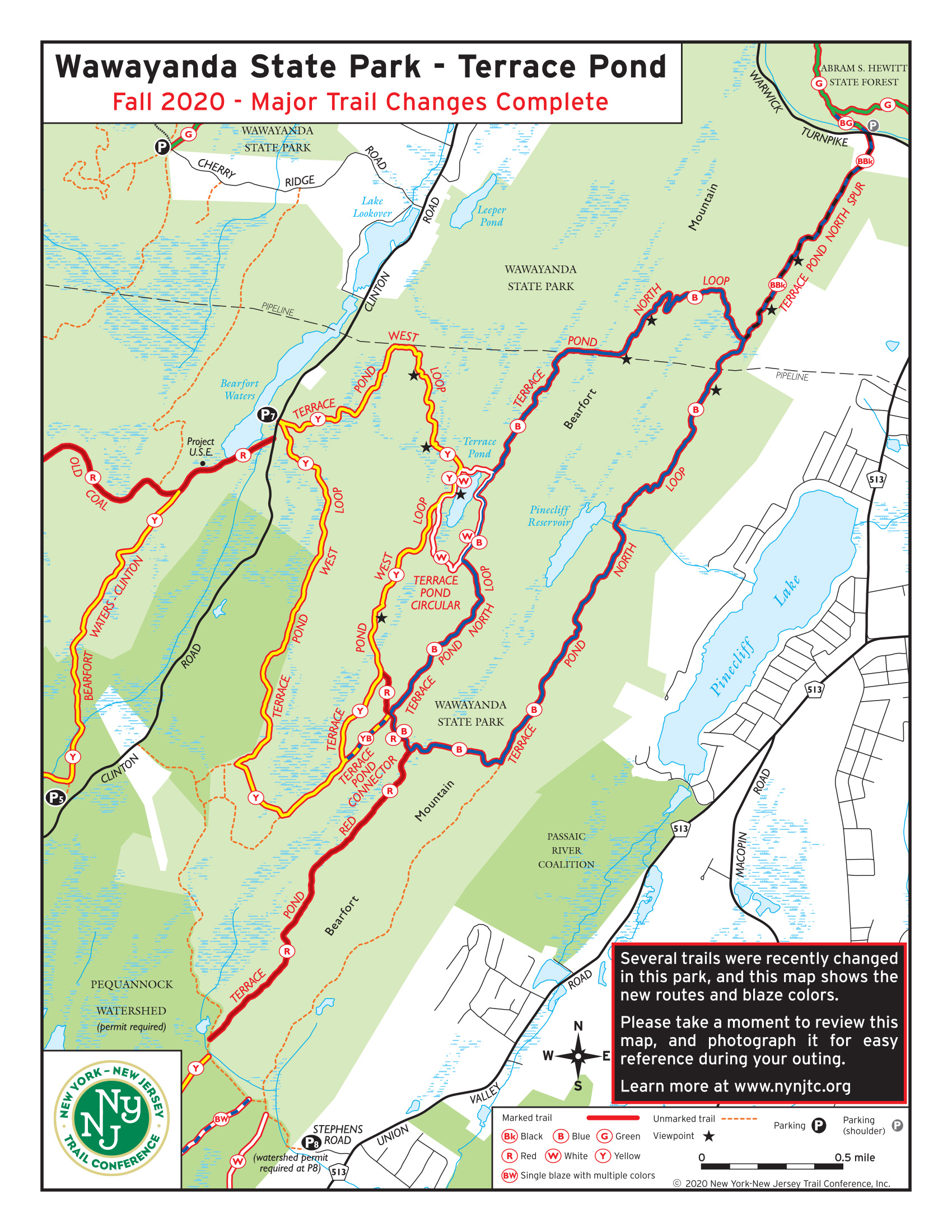
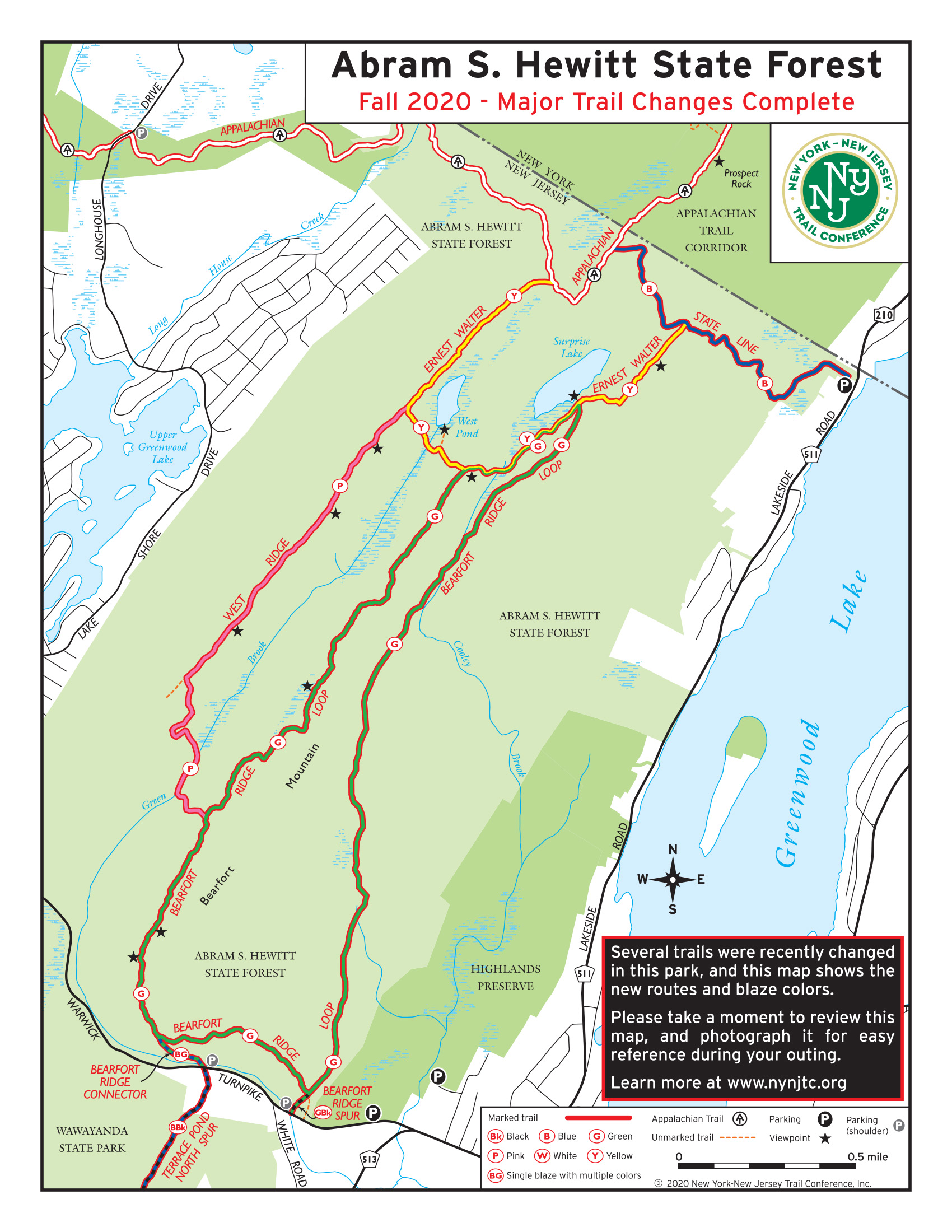
Wawayanda State Park and Abram S. Hewitt State Forest
- View the Wawayanda State Park completed major trail changes map.
- View the Abram S. Hewitt State Forest completed major trail changes map.
In Wawayanda State Park and Abram S. Hewitt State Forest, Trail Chair Nick McKenna played a crucial role in planning and implementing trail changes. “Bearfort Ridge boasts some of the best hiking in New Jersey, with grand views from the mountaintop overlooks and stunning ponds hidden between the ridges,” says McKenna. “For nearly 15 years, it has been my honor and privilege to care for the trails in this special and unique area. This project represents the biggest change to the region's trails in more than a generation—changing popular loop hikes into a single color to reduce lost hikers, while also creating appealing new options for experienced and adventurous hikers as well.”
Supervisor Keith Scherer also played an integral role in making these on-the-ground changes. Scherer, who admits he was “a geeky 12-year-old” when he got my first Trail Conference map, says he has been looking forward to the Trail Conference Centennial for 30 years. “Given the circumstances,” he says, “I could not think of a better way to celebrate: planning and building trails to get people outside and connecting with nature, the way 100 years of volunteers did before me. What a way to celebrate! McKenna, Scherer, and their team have contributed 285.5 hours creating the following new trails:
- Terrace Pond North Loop: The recent conservation of a vulnerable piece of land off Warwick Turnpike in partnership with The Land Conservation of New Jersey ensures that access to this trail will be protected in perpetuity. The incorporation of a new trail section turns this previously linear hike into a satisfying loop.
- Terrace Pond West Loop: Existing trails and woods roads create a loop from Clinton Road that offers diverse forests and swamp views while leading you to Terrace Pond.
- Terrace Pond Circular: While this trail is unchanged from its historic route, the addition of a spectacular new floating walkway (discussed on page 12) makes this scenic path worth a visit, even for those who have walked it before.
- Bearfort Ridge: Located in Abram S. Hewitt State Forest, existing trails create a loop hike option from the parking lots on Warwick Turnpike. Incorporating the newly adopted West Ridge Trail offers an expanded hike option for those looking to put in more miles.
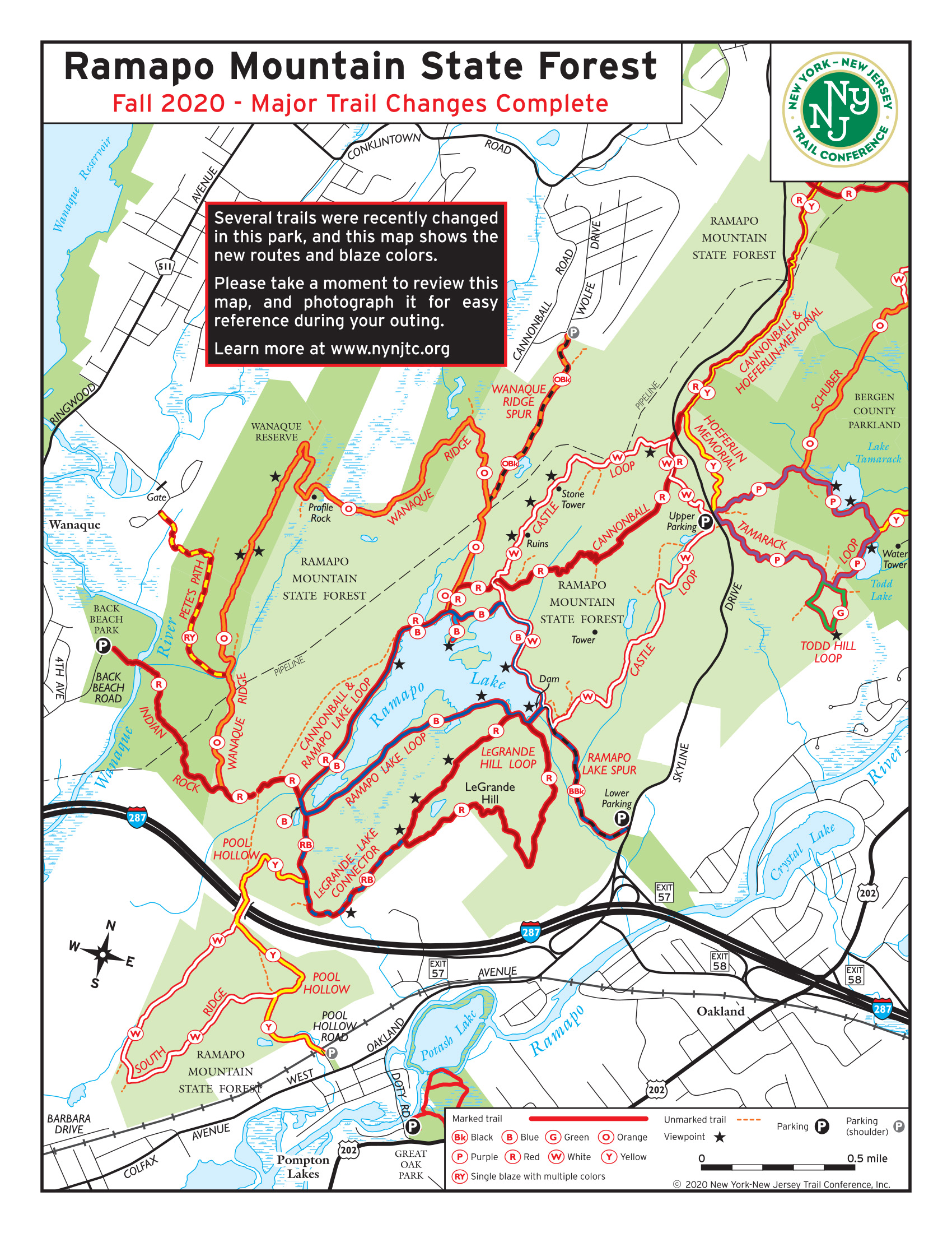
Ramapo Mountain State Forest and Ringwood State Park
- View the Ramapo Mountain State Forest completed major trail changes map.
- View the Ringwood State Park completed major trail changes map.
In Ramapo Mountain State Forest, Regional Trail Chair Chris Connolly has been working all summer at a heated pace (literally) to create four new loop experiences, blazed using existing trails. These loops will allow visitors to follow one blaze color along 2- to 4-mile circuits to popular destinations like Ramapo Lake, the Castle ruins, and Tamarack/Todd lakes. In the past, completing one of these popular loops required linking together multiple trails; hikers of the Castle Loop, for example, previously had to follow five different blaze colors to complete this circuit through the dense local trail network. Even experienced map-users should appreciate the ease of following this trail without having to pull out the map at every intersection.
This fall, Chris caps off a productive season with the creation of the Five Ponds Loop in Ringwood State Park. This loop uses existing trails and previously unmarked woods roads to take visitors to five of Ringwood’s most scenic water bodies. "Trail design includes making it as simple as possible for users to experience great outdoors places, and single-blaze loop hikes are just about the simplest way to do that," says Connolly. Here’s where the efforts of his team can be experienced:
- Castle Loop: Existing trails create a loop hike from the upper Skyline Drive parking lot, taking visitors to the popular Van Slyke Castle ruins and alongside scenic Ramapo Lake.
- Ramapo Lake Loop: Already a popular hike, this trail departs from the lower Skyline Drive parking lot and connects to a convenient loop around Ramapo Lake.
- LeGrande Hill Loop: Previously the Lookout Trail, this existing route circles LeGrande Hill with beautiful views of Ramapo Lake.
- Tamarack Loop: This circuit builds the relatively new Tamarack Trail into a self-contained waterside loop experience from the upper Skyline Drive parking lot.
- Todd Loop: This “bonus loop” stacks nicely onto the new Tamarack Loop for hikers looking for a little extra distance and another vista on their journey.
- Five Ponds Loop: This game-changer of a trail will take you to five of Ringwood’s most beautiful ponds and water bodies, and promises to become one of the park’s hiking destinations. As a bonus, the trailhead parking lot has ample space to accommodate visitors even when other areas are overflowing.
We hope you have a chance to come out and explore these trails, whether you’re a new hiker looking to gain confidence or a veteran explorer looking to see what stacked-loop routes you can make from these new configurations.
Comment: Please be relevant, civil, non-commercial.
New Loop Trails - Abram Hewitt & Norvin Green SF
Re: revised North Jersey maps on Avenza Maps
~Jeremy, TC cartographer
Thanks, Avenza is great. And
When will a revised North Jersey map set be available?
Re: revised North Jersey map set
Thanks Shani, I do hope you enjoy the maps!
Generally, we update our maps in a 2-4 year timeframe, and our North Jersey maps were published just over 3 years ago. We are hoping to have a revised North Jersey map set available in early 2021. You can check our North Jersey map page (https://www.nynjtc.org/maps/north-jersey-trails-map) for the latest updates for now. The updated maps will feature all of these trail changes, as well as some other new trails in other parks. We are also exploring other possible changes, including potentially showing the junction-to-junction trail mileage numbers, so definitely stay tuned!
~Jeremy, TC cartographer
Thanks, Jeremy!